UM News&Information
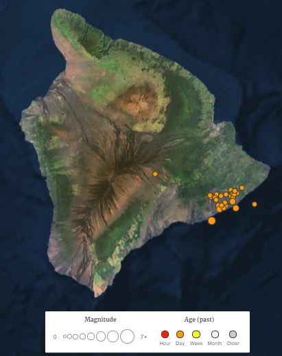
May 4Hundreds of small and a few larger earthquakes have occurred in the past week—including a magnitude-5 on May 3—indicating that magma in the Kilauea volcano is on the move. Several surface fissures with magma fountains have already formed, and evacuation planning is under way for thousands of residents.
This type of eruption is less dangerous to human life than stratovolcanoes like Mount St. Helens and Mount Pinatubo, which are characterized by explosive volcanism and large ash clouds that reach into the stratosphere,” van der Pluijm said. “Hawaiian volcanoes are characterized by red-hot magma that bubbles and flows, and minor explosive activity. However, flowing hot lava destroys everything in its path. The Big Island is the most recent expression of millions of years of volcanism along the Hawaiian chain.
May 9
Kilauea has been continuously erupting for more than 35 years. Though this recent activity is a more active episode, it is not otherwise unusual. With about 100 acres covered by new lava flows, this latest Kilauea flare-up produced less than 1 cubic kilometer (about 0.2 cubic mile) of eruptive volume so far, which is a modest amount in the volcano's history.
More than 1,000 shallow earthquakes reflect recent deep magma movement, fissures and subsurface displacements, including two larger quakes that rocked the area in the past week. These displacements have resulted in about 2 feet of seaward, southeast-directed movement of the volcano's south flank. Potential instability of Kilauea's south flank adds a Pacific tsunami hazard risk if land collapses into the sea.
More than 1,000 shallow earthquakes reflect recent deep magma movement, fissures and subsurface displacements, including two larger quakes that rocked the area in the past week. These displacements have resulted in about 2 feet of seaward, southeast-directed movement of the volcano's south flank. Potential instability of Kilauea's south flank adds a Pacific tsunami hazard risk if land collapses into the sea.
May 17
Any danger is limited to the easternmost part of the Big Island. These types of eruptions are not that violent, except the potential of occasional steam-driven explosions that throw ash and rocks around in a small area. Better to keep some distance, and evacuate, regardless,” he said.
Fissure eruptions and slowly flowing lava are characteristic for the Big Island geology, with explosivity less common but recorded in prior eruptive events in the area as well. The origin of explosions is not the magma type, but heated water, somewhat analogous to a Yellowstone geyser.
Twitter (@vdpluijm)
May 1Collapse of crater floor on #Kilauea Volcano’s East Rift Zone prompts increase in #seismic activity. More lava coming? #Hawaii #volcano #geology
May 4
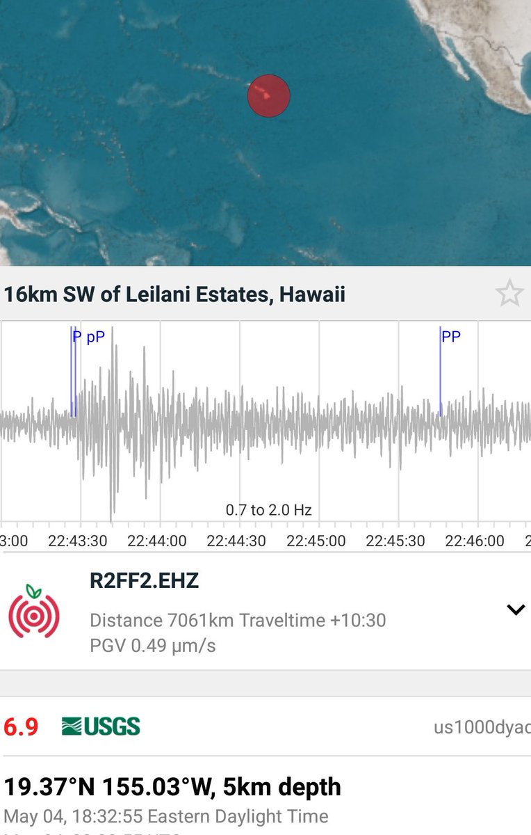
M6.9 was 7000 km away and my home shook 11 min later (well, my basement seismometer felt it). @raspishake #earthquake
May 9
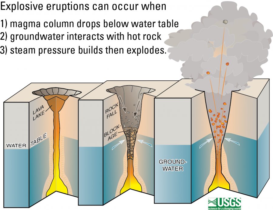
The other source of explosive volcanism, driven by magma submersion below groundwater table, not (silicic) composition of the magma. Dangerous as well.
This diagram shows how explosive eruptions occur at Kilauea: 1) lava column drops below the water table; 2) groundwater comes in contact with magma or hot rocks, 3) the flash boiling of water causes violent steam explosions.
May 12
Nicely illustrated summary of 2018 #Kilauea eruption event thus far, and its impact. More lava (and ash?) may be ahead. #Resilience #geohazard -- ‘Shell-Shocked’ in #Hawaii: How Lava Overran a Neighborhood

May 14
The Pacific Tsunami Warning Center created an animation of recent earthquake and volcano activity at Hawaii's Kīlauea Volcano, from April 21 to May 13, 2018. Thousands of small (<M3) and a few larger earthquakes, in addition to multiple fissure eruptions. Kilauea is not likely done, with more honey-like lava (effusive eruption) ahead and perhaps some steam-powered explosivity (phreatic eruption). #hawaii #geohazards -- youtu.be/bm9ezJQBOXs
May 17
May 14 Landsat image of Kilauea eruption region (+ some clouds). Red marks active vents; recent flows gray; forest green; houses white. Notice formally bubbling Pu’u ’O’o vent is now drained and a steady plume at Kilauea.

May 24
Lighter touch: The importance of Hawaii lava flows.

Whereas media coverage of #KilaueaEruption has waned, volcanism has not. Several M5+ quakes and many smaller mark recent magmatic activity in crater region ("poolball").

See @NOAA #earthquake animation through May 31: youtu.be/CybGAooIGZY.
June 7&8
Just like significant tectonic plate boundary earthquakes have recurrence intervals (decades to centuries), so seemingly do volcanic earthquakes. Kilauea's are 1-2 days leading to M5+. M5 is equivalent to ~500 ton #TNT explosion.
... June's fifth M5+ #earthquake in #Kilauea caldera, like clockwork. Growing foreshock pattern is distinct from tectonic quakes that are characterized by aftershocks. Depth-magnitude-time plot (from VolcanoDiscovery):

June 11
Is Kilauea the new and bigger "Old Faithful"? Not exactly, but steady daily recurrence of M5+ earthquakes and venting continues. Persistent absence of M4-5 quakes in caldera is a head scratcher (see plot), but may represent different processes in the volcano.

July 6
Hawaii's "New Faithful" volcano continues with #earthquakes like clockwork. On average just over 1 day (~1.2) between explosions in #Kilauea. Surprisingly consistent pressure cycling in its plumbing.

July 21
Kilauea lava eruption and its future reported by USGS:
- >430M m3 lava erupted so far is largest in centuries.
- lava delta extends >800m from pre‐eruption Kapoho Bay coastline.
- eruption may continue months to years.
https://volcanoes.usgs.gov/vsc/file_mngr/file-185/USGS%20Preliminary%20Analysis_LERZ%20July%2015%202018.pdf

Lava delta. une 18, 2018 (USGS)
August 8
Hawaii's Kilauea volcano hits pause button. Little lava flowing, no explosive earthquakes at caldera. At best, a geologic pause (=yrs, decades), but may also be only a human pause (=days, weeks). Activity will return, so stay alert, BigIslanders.

Kīlauea's summit is quiet. August 2 (USGS)
August 14
Kilauea update. The geologic pause of lava flow and explosions continues, while coastlines redrawn (pic of new Pohoiki Bay). Flows not yet cold, but bill is, like the #BigIsland, growing: $680M. Cost of predictable #geohazards will be unsustainable.

Pohoiki Bay. August 12 (USGS)