Friday, July 20, 2018

The Meghalayan?

I actually posted “WTF is the Meghalayan?" on Twitter (here).  This in response to the IUGS’s announcement that the Holocene Epoch was officially divided into new stages.  The Meghalayan stage, after a location in NE India, being the youngest, so the one we are living in today.  Two thoughts came to my mind quickly: (1) how thin are we slicing geologic time?; and (2) what about the Anthropocene?


The relevant section is:


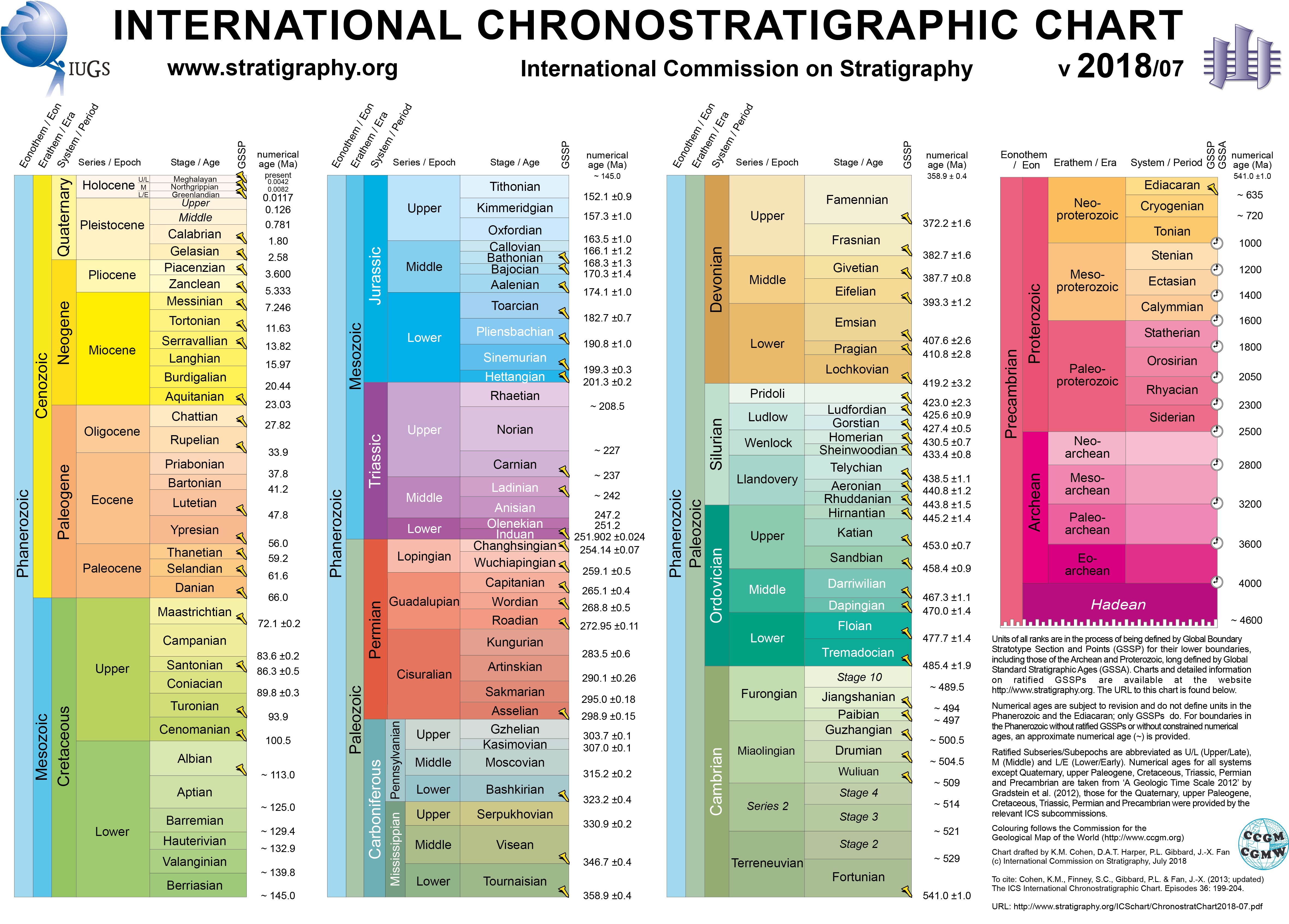
As the new chart shows, the Holocene is now sliced into three roughly 4000y stages.  That is short, faster than a geologic eye blink, with subtle boundaries.  Perhaps a little silly.  How small can relevant slices go, I wondered.  Jokingly, I proposed:
Kennedyan 1950-1963; Dallas
Lennonian 1964-1980; Abbey Road
Mandelaian 1981-2013; Robben Island
With time on my hands, I even identified the location of the required Golden Spike for each:


More seriously, I wondered about the status of an eventual Anthropocene in the official time chart.  A large working group has been debating this for several years ongoing, seemingly close to deciding on 1950 as the beginning of that time.  I favor the idea to emphasize the growing role of humans in the geologic system; for example, our large resource and land use, environmental change of ocean and atmosphere, etc. However, I'd place the start earlier, as impacting global colonization and industrial revolutions occurred 100s of years earlier and agricultural appropriations 1000s of years earlier.

I doubt agreement on a start will be easy, so instead I propose that we replace Holocene with Anthropocene (the Epoch of human emergence and dominance) and relegate Holocene as a Stage/Age (the last glacial deposits and a warming planet).  The huge changes of the past 150-200 years would be captured by the Modern Age, which is recognizable and already used informally.  My proposal below.


I have little idea what will come of this, but, hopefully, some fresh discussions on the meaning of the geologic time scale and the value of identifying geologic boundaries. The process of decision making is decadal, so I am not holding my breath.  I was surprised, however, that officials made another move.

Deposit of the Modern Age with plastic and aluminum "fossils" (Kobe, Japan).

A nice piece in The Atlantic, “There’s No Collusion”: Geology’s Timekeepers Are Feuding
-- “It’s a bit like Monty Python." offers some background on process and value, and may help this discussion along.  It includes my lighthearted characterization of the process as the "Ministry of Silly Cuts" (maybe not helping things along).  Enjoy this well-written The Atlantic piece and see that geologists are people too, with intrigue and tensions.


In the end, the discussion and decisions should revolve around recognizing the changes and challenges facing modern society as we have to rely on Earth for the foreseeable future, and the contributions of geology to our actions in a changing world.

May 2019
Disappointingly, but not unexpected, the Anthropocene Working Group selects 1950 as the start of the Anthropocene.  Baby Boomers rule, but showing little regard for the geologic timescale.  Perhaps a GoT-like redo on change.org with 1.5+M signatures?
See: https://www.nature.com/articles/d41586-019-01641-5

---------------
Follow Ben van der Pluijm on Twitter as @vdpluijm; for example:


Wednesday, June 13, 2018

Talking Volcanoes and Hazards

Volcanoes in Hawaii, Guatemala: Faculty Q&A

More than 100 people were killed and nearly 200 remain missing after the violent eruption of Guatemala’s Fuego volcano June 3. Meanwhile, lava has destroyed more than 600 homes on Hawaii’s Big Island since early May in the latest eruption of the Kilauea volcano.


University of Michigan geologist Ben van der Pluijm, a professor in the Department of Earth and Environmental Sciences and editor-in-chief of the journal Earth’s Future, examines the impacts of natural hazards on human society. He discussed the two recent volcanic eruptions.

What are the main differences between the Kilauea volcano in Hawaii and the Guatemala’s Fuego volcano?

Hawaii’s volcanoes, like Kilauea, are caused by heat in the Earth’s mantle rising to the surface in a column called a plume. Hawaiian volcanoes mostly produce slow-moving, gooey lava, creating a broad, low-topography structure called a shield volcano. The biggest hazard from these volcanoes is unstoppable magma flow, and the latest Kilauea eruption has already destroyed many hundreds of houses. But because the lava moves slowly and can be outpaced, these events typically cause no loss of life or major injuries.

Explosive volcanoes like Guatemala’s Fuego have a very different origin from Hawaii’s. They are related to plate-boundary tectonic processes that produce a stickier magma in the outer layers of Earth. Greater magma stickiness resists buildup pressure from below until it releases in a sudden, explosive manner. These eruptions are quick and large, and they often produce deadly clouds of hot ash, lava, rock and gas that roll downslope at great speed: a hot pyroclastic flow. This is the primary source of the great loss of life in Guatemala, much like Pompeii from the Vesuvius eruption in the first century.

What can we expect from these two volcanoes in the coming weeks and months?

Kilauea has been erupting for more than a month and may be reaching the end of its current cycle. Another eruption cycle will eventually follow, however, because the driver for magma generation persists, and the volcano has been regularly erupting for decades.

Fuego released most of its energy in the early eruption, so it may become quiet. As elsewhere, however, the volcanism won’t stop. It simply takes a hiatus. Other volcanoes in the region may similarly erupt at some point, since the underlying magma-generating process—melting from convergent plate tectonics—continues unabated.

The voluminous ash and rock deposits that are left behind after a Fuego-style explosion are often unstable on steep mountain slopes, especially when rain wets the material. These deposits can wash downslope as dense, debris-rich, destructive flows known as cold mudflows. These flows can destroy houses and agricultural land, covering the area with mud and rocks.

How common are volcanic eruptions globally?

Worldwide, several dozen volcanoes are erupting at any given time. Several hundred volcanoes around the globe, including more than 160 in the United States, are considered active, meaning that they have erupted in historic time. The Kilauea and Fuego eruptions are therefore not at all unusual or unexpected, except they have greater impacts on nearby human settlements than other active volcanoes around the world.

What technologies are used to forecast volcanic eruptions?

Many volcanoes show seismic activity as pressure builds and magma starts to move around. We measure this seismic signal with local seismometers stationed near and on the volcano. Another gauge of possible eruptive activity is the use of surface tilt meters that measure ground deformation from inflation of the volcano in response to moving magma. Also, remote sensing and satellites are increasingly employed to monitor changes around active volcanoes.

Thus, volcanoes can offer some precursor activity, but uncertainty toward full eruption remains too large for reliable societal prediction, and the warning period before an eruption can be short. Instead, people living near active volcanoes need to be informed and prepared because those volcanoes will, eventually, become active again.

What is the connection between the Kilauea eruption and the earthquakes that have been occurring there for more than a month now?

The generation and movement of magma beneath Kilauea creates pressure changes in the subsurface that generate earthquakes from rock fracturing. And inside Kilauea’s volcanic depression, which is called a caldera, earthquakes occur when magma pressure is released by rock collapse and fracturing, and by venting at the surface.

During its latest eruption, Kilauea has displayed a remarkable pattern of repeated earthquakes of magnitude 5 or greater, equivalent to the explosion of 500 tons of TNT. These events are often associated with ash eruption, following a one- to two-day pressure buildup. This seismic activity will eventually subside.

Ben van der Pluijm posts about geohazards and societal impacts on Twitter as @vdpluijm. A selection of Kilauea Twitter posts are archived at https://vdpluijm.blogspot.com/2018/05/kilauea-2018.html

June 2018; from Michigan News, https://news.umich.edu/volcanoes-in-hawaii-guatemala-u-m-expert-discusses/

Saturday, May 12, 2018

Kilauea 2018 eruption

UM News&Information

May 4
Hundreds of small and a few larger earthquakes have occurred in the past week—including a magnitude-5 on May 3—indicating that magma in the Kilauea volcano is on the move. Several surface fissures with magma fountains have already formed, and evacuation planning is under way for thousands of residents.

This type of eruption is less dangerous to human life than stratovolcanoes like Mount St. Helens and Mount Pinatubo, which are characterized by explosive volcanism and large ash clouds that reach into the stratosphere,” van der Pluijm said. “Hawaiian volcanoes are characterized by red-hot magma that bubbles and flows, and minor explosive activity. However, flowing hot lava destroys everything in its path. The Big Island is the most recent expression of millions of years of volcanism along the Hawaiian chain.

May 9
Kilauea has been continuously erupting for more than 35 years. Though this recent activity is a more active episode, it is not otherwise unusual. With about 100 acres covered by new lava flows, this latest Kilauea flare-up produced less than 1 cubic kilometer (about 0.2 cubic mile) of eruptive volume so far, which is a modest amount in the volcano's history. 

More than 1,000 shallow earthquakes reflect recent deep magma movement, fissures and subsurface displacements, including two larger quakes that rocked the area in the past week. These displacements have resulted in about 2 feet of seaward, southeast-directed movement of the volcano's south flank. Potential instability of Kilauea's south flank adds a Pacific tsunami hazard risk if land collapses into the sea.

May 17
Any danger is limited to the easternmost part of the Big Island. These types of eruptions are not that violent, except the potential of occasional steam-driven explosions that throw ash and rocks around in a small area. Better to keep some distance, and evacuate, regardless,” he said.

Fissure eruptions and slowly flowing lava are characteristic for the Big Island geology, with explosivity less common but recorded in prior eruptive events in the area as well. The origin of explosions is not the magma type, but heated water, somewhat analogous to a Yellowstone geyser.

Twitter (@vdpluijm)

May 1
Collapse of crater floor on #Kilauea Volcano’s East Rift Zone prompts increase in #seismic activity.  More lava coming? #Hawaii #volcano #geology

May 4

M6.9 was 7000 km away and my home shook 11 min later (well, my basement seismometer felt it). @raspishake #earthquake

May 9
The other source of explosive volcanism, driven by magma submersion below groundwater table, not (silicic) composition of the magma.  Dangerous as well. 
This diagram shows how explosive eruptions occur at Kilauea: 1) lava column drops below the water table; 2) groundwater comes in contact with magma or hot rocks, 3) the flash boiling of water causes violent steam explosions.


May 12
Nicely illustrated summary of 2018 #Kilauea eruption event thus far, and its impact. More lava (and ash?) may be ahead.  #Resilience #geohazard  -- ‘Shell-Shocked’ in #Hawaii: How Lava Overran a Neighborhood


May 14
The Pacific Tsunami Warning Center created an animation of recent earthquake and volcano activity at Hawaii's Kīlauea Volcano, from April 21 to May 13, 2018. Thousands of small (<M3) and a few larger earthquakes, in addition to multiple fissure eruptions. Kilauea is not likely done, with more honey-like lava (effusive eruption) ahead and perhaps some steam-powered explosivity (phreatic eruption). #hawaii #geohazards -- youtu.be/bm9ezJQBOXs

May 17
May 14 Landsat image of Kilauea eruption region (+ some clouds).  Red marks active vents; recent flows gray; forest green; houses white.  Notice formally bubbling Pu’u ’O’o vent is now drained and a steady plume at Kilauea.

May 24
Lighter touch: The importance of Hawaii lava flows.
June 3
Whereas media coverage of #KilaueaEruption has waned, volcanism has not.  Several M5+ quakes and many smaller mark recent magmatic activity in crater region ("poolball").  

See @NOAA #earthquake animation through May 31: youtu.be/CybGAooIGZY. 

June 7&8
Just like significant tectonic plate boundary earthquakes have recurrence intervals (decades to centuries), so seemingly do volcanic earthquakes.  Kilauea's are 1-2 days leading to M5+. M5 is equivalent to ~500 ton #TNT explosion.
... June's fifth M5+ #earthquake in #Kilauea caldera, like clockwork.  Growing foreshock pattern is distinct from tectonic quakes that are characterized by aftershocks. Depth-magnitude-time plot (from VolcanoDiscovery):

June 11
Is Kilauea the new and bigger "Old Faithful"? Not exactly, but steady daily recurrence of M5+ earthquakes and venting continues.  Persistent absence of M4-5 quakes in caldera is a head scratcher (see plot), but may represent different processes in the volcano. 

July 6
Hawaii's "New Faithful" volcano continues with #earthquakes like clockwork.  On average just over 1 day (~1.2) between explosions in #Kilauea. Surprisingly consistent pressure cycling in its plumbing. 

July 21
Kilauea lava eruption and its future reported by USGS: 
- >430M m3 lava erupted so far is largest in centuries. 
- lava delta extends >800m from pre‐eruption Kapoho Bay coastline. 
- eruption may continue months to years.

https://volcanoes.usgs.gov/vsc/file_mngr/file-185/USGS%20Preliminary%20Analysis_LERZ%20July%2015%202018.pdf
Lava delta. une 18, 2018 (USGS)

August 8
Hawaii's Kilauea volcano hits pause button. Little lava flowing, no explosive earthquakes at caldera. At best, a geologic pause (=yrs, decades), but may also be only a human pause (=days, weeks). Activity will return, so stay alert, BigIslanders. 
Kīlauea's summit is quiet. August 2 (USGS)

August 14
Kilauea update. The geologic pause of lava flow and explosions continues, while coastlines redrawn (pic of new Pohoiki Bay). Flows not yet cold, but bill is, like the #BigIsland, growing: $680M. Cost of predictable #geohazards will be unsustainable.
Pohoiki Bay. August 12 (USGS)


Thursday, February 01, 2018

A Meteor in Michigan: Some Seismicity and Some Geometry

On January 16, a little after 8:08pm local time, a bright flash lighted the sky, and by some, even a bang was heard.  An object, a meteor, that earlier had entered our atmosphere became so heated by air friction that it exploded.  Some have reported surface recovery of small fragments of the object near the explosion.

Have a look at videos of the object and its explosion flash here: https://goo.gl/uwoqp1 (from MLive).

The explosion was recorded by several seismic stations in the region, with the AAM station of Ann Arbor showing a remarkably clean signal (below). The USGS calculated the magnitude as M2 based on groundshaking, but the source is very different from earthquake-generating fault motion in the solid Earth. Let’s use some basic geometry to learn a bit more about the event.


Observations place the flash about 30km north from the Ann Arbor-AAM seismic station.  The energy of the flash reached the AAM station at 8:10:15pm local time, meaning that ~100 seconds had passed since the reported 8:08:33pm time of the flash [best time estimate from posted videos].   This allows us to test whether the energy passed through the atmosphere or the solid Earth, or a combination.  Compressive (P) waves travel about 340m/sec in the lower atmosphere, while P ground waves travel ~5000m/sec in the rocks of Michigan.

Air waves
If the energy source is an explosion in air, than 100sec x 340m/sec gives a distance to the explosion of 34km.  With a horizontal distance of 30km, trigonometry gives an elevation for the explosion of ~16km above the surface.  The slow speed of the object indicates that it was already deep into our atmosphere, so this elevation seems reasonable.

Ground waves
If the energy is from impact of the object, then ~50km distance of the projected impact point to the AAM station at solid Earth wave speeds, means that the energy would have reached the station in ~10 seconds.  This short time neither matches the timing of events, nor observation of scattered meteorite pieces before the projected impact point.

Air and ground waves
If the energy was transferred by waves traveling from the surface location to the AAM station, the travel time would have been 30,000m ÷ 5000m/s, is 6 seconds.  Thus the soundwave in the atmosphere would have traveled ~95 seconds from explosion to surface, meaning an elevation of 95sec x 340m/sec, is 32 km.  Twice that of the sound waves through air only scenario above, and a little high.

Looking at the lower WNW trajectory of the meteor, the angle was estimated at 30o from the projected surface intersection of its path, which is about 30 km from the explosion.  Using trigonometry, this means that the explosion occurred at an elevation of ~17km.  This estimate matches the first, air-only calculation of elevation very well, but not the calculation involving solid Earth groundwaves.

We learn from the Ann Arbor seismic record and reported timing of events that regional shaking associated with the exploding MI meteor is from the pressure of sound waves passing through air.  This pressure was enough to shake buildings and be heard locally, and move the ground surface over several 10s of km.  The exploding object did not significantly pass groundwaves through solid Earth, nor was physical impact of the object a source of energy.  Given the USGS M2 equivalence of groundshaking, we also can try to estimate the surface expression of the explosion at ~16km elevation.  Whereas an M2 earthquake is equivalent to exploding several tens of kg of TNT in solid material, a real calculation of the explosive power at elevation in the atmosphere is beyond my abilities.

So, a seismic station, citizen observations and basic trigonometry illuminate some details of a January 16 exploding meteor over Michigan that mesmerized local scientists and the public alike.

Thanks to my office colleagues Eric Hetland, Yihe Huang and Jeroen Ritsema for fun conversations.

Follow Ben van der Pluijm on Twitter: @vdpluijm